Know the Numbers...
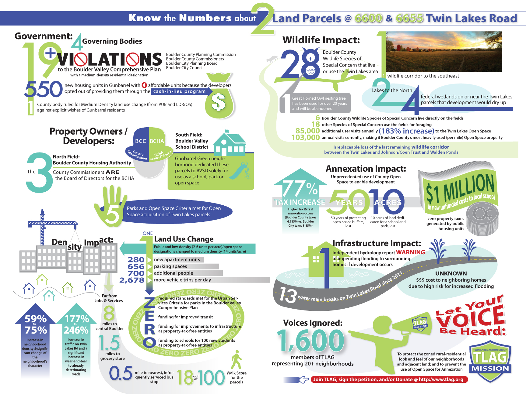
2 Parcels of Land: 6600 & 6655 Twin Lakes Road
Government:
4 Governing Bodies: Boulder County Commissioners, Boulder County Planning Commission, Boulder City Council, Boulder City Planning Board
19+ Violations to the Boulder Valley Comprehensive Plan with a medium-density residential designation
1 County Body have ruled for Medium Density land use change (from PUB and LDR/OS) against the explicit wishes of Gunbarrel residents
550 new housing units in Gunbarrel with 0 affordable units because the developers opten out of providing them through the cash-in-lieu program
Property Owners / Developers:
North field: Boulder County Housing Authority – the 3 County Commissioners ARE the board of directors for the BCHA
South field: Boulder Valley School District the Gunbarrel Greens neighborhood dedicated these parcels to BVSD solely for the use as a school, park or open space
Density Impact:
1 Land Use Change Low Density (2-6 units per acre) and Public to Medium Density (14 units per acre)
280 new apartment units, 656 parking spaces, ~700 additional people, ~2,678 more vehicle trips per day
59% to 75% increase in neighborhood density & significant change of the neighborhood’s character
177% to 246% increase in traffic on Twin Lakes Rd and a significant increase in wear-and-tear to already deteriorating roads
5 Parks and Open Space Criteria met for Open Space acquisition of Twin Lakes parcels
Zero required standards met for the Urban Services Criteria for parks in the Boulder Valley Comprehensive Plan
Zero funding for improved transit
Zero funding for improvements to infrastructure as property tax-free entities
Zero funding to schools for 100 new students as property tax-free entities
Far from jobs and services:
8 miles to central Boulder
1.5 miles to grocery store
0.5 miles to nearest, infrequently serviced bus stop
18 out of 100 Walk Score for the parcels
WILDLIFE IMPACT:
28 Boulder County Wildlife species of Special Concern that live or use the Twin Lakes area
1 wildlife corridor to the southeast
2 Lakes to the North
4 federal wetlands on or near the Twin Lakes parcels that development would dry up
1 Great horned owl nesting tree has been used for over 20 years and will be abandoned
6 Boulder County Wildlife Species of Special Concern live directly on the fields
18 other Species of Special Concern use the fields for foraging
85,000 additional user visits annually (183% increase) to the Twin Lakes Open Space
103,000 annual visits currently, making it Boulder County's most heavily used (per mile) Open Space property
Irreplaceable loss of the last remaining wildlife corridor between the Twin Lakes and Johnson/Coen Trust and Walden Ponds
Annexation Impact:
Unprecedented use of County Open Space to enable development
77% higher Tax Rate if annexation occurs (Boulder County taxes 4.985% vs. Boulder City taxes 8.85%)
50 years of protecting open-space buffers, lost
10 acres of land dedicated for a school and park, lost
$1 million in new unfunded costs to local school
$0 property taxes generated by public housing units
Infrastructure Impact:
1 independent hydrology report warning of impending flooding to surrounding homes if development occurs
Unknown $ cost to neighboring homes due to high risk for increased flooding
13 water main breaks on Twin Lakes Road since 2011
Voices Ignored:
1,600 members of TLAG representing 20+ neighborhoods
TLAG Mission:
To protect the zoned rural-residential look and feel of our neighborhoods and adjacent land; and to prevent the use of Open Space for Annexation